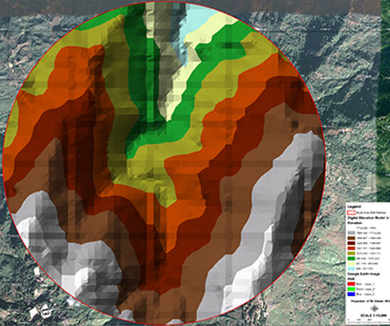
The term topography was given a whole new meaning with the advent of satellite based remote sensing and modern aerial photography which have the ability to derive continuous surface information via means of radar beams, laser beams or optical cameras. With the introduction of these new possibilities and techniques many users now have the ability to understand and analyze the biological, physical, cultural and chemical character of the earth's surface. In this regard the elevation data and information is represented in computerized digital format in what is known as the development of digital elevation models or DEMs.
The DEM is therefore a computerized depiction of Earth's relief. DEM can be executed using various formats out of which the most typically used formats are the TIN or Triangulated Irregular Networks, contour lines, regular grids and scattered data points. Digital elevation models are represented by image matrixes or wire frames. These models are used in combination with many other spatial information and data and it is a vital tool used for database purposes, 3D animation such as fly throughs and topography related analyses. ORPAX provides expert services for development of digital elevation models for all kinds of users.
Our unique GIS and DEM services can be used separately or together. The development of digital elevation models, digital image processing and GIS technology has all become rapidly expanding sectors in the recent years. Particular significance has been witnessed in treatment of image and geo information in commercial, operational and scientific applications. A large number of applications in these fields find DEM to be an integral and important part.
We develop digital elevation models for all types of:
- Industrial applications
- Commercial applications
- Scientific applications
- Military applications
- Operational applications
Our solutions have the capacity of enhancing analysis capabilities and invoking superior results and our models play an important role in the decision making and product development process of any organization. We foresee development of digital elevation models as useful asset needed in a variety of commercial and public sectors such as navigation, telecommunications, transportation, energy, weather forecast, disaster management, remote sensing, land cover classification, geodesy and civil engineering among many others.
Our models are developed with the aim of assisting professional who rely on accurate and detail terrain knowledge. Therefore engineering firms involved in various infrastructure development projects can make use of our DEMs to complete their feasibility reports more easily, accurately and speedily with up to date depiction of geospatial information. We help in enhancing the decision making process, control operating costs and better evaluate the global investments.
We cater for resource exploration needs, geological terrain analysis, field surveys, assessment of natural resources without 3D subsurface modelling techniques. Civil security agencies and organizations can make use of our models for mapping out flood hazard zones, estimate slopes and ascertain flow path directions.
With our DEMs, users are given the opportunity of accessing a multi resolution capability. We are willing to edit our outputs according to client specifications to produce a high quality terrain representation. With us, you can be assured of utilizing the latest innovations and we ensure providing our valued customers with a state of the art service complete with management excellence. Our products and services are optimized for smartness, agility and perfect alignment with your end expectations.
